A) reconstructions of seafloor spreading
B) rock types and structures
C) magnetism stored in rocks
D) all of these
E) a and b only
G) C) and E)
Correct Answer

verified
Correct Answer
verified
Multiple Choice
What geologic events are expressed in this cross section of the western U.S. in late Paleozoic - early Mesozoic time? 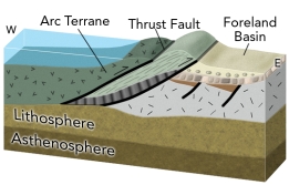
A) an old episode of continental rifting that lead to a passive margin
B) collision of an island arc with western North America
C) oceanic crust and sediment that was thrust onto North America
D) a basin formed by the weight of thrust sheets
E) all of these
G) All of the above
Correct Answer

verified
Correct Answer
verified
Multiple Choice
What tectonic event in the western U.S. caused magmatism and deformation to move farther into the continent during the late Mesozoic and early Cenozoic Laramide Orogeny?
A) the continent overran a hot spot
B) the continent overran the East Pacific Rise
C) continental extension stretched the continent to twice its original width
D) an oceanic plate subducted at a low angle beneath the continent
F) A) and C)
Correct Answer

verified
Correct Answer
verified
Multiple Choice
In the region shown in this figure, what is the most likely cause for a basin between the arc and continent? 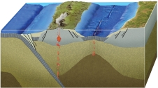
A) it is a foreland basin
B) it is an accretionary prism
C) it formed by back-arc rifting and spreading
D) it formed by strike-slip motion during a continental collision
F) A) and C)
Correct Answer

verified
Correct Answer
verified
Multiple Choice
If you had this type of deformation of a region, it would: 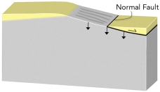
A) thicken the crust and cause subsidence
B) thicken the crust and cause uplift
C) thin the crust and cause subsidence
D) thin the crust and cause uplift
E) none of these
G) B) and D)
Correct Answer

verified
Correct Answer
verified
Multiple Choice
Which of the following is NOT a setting in which regional mountain belts form?
A) continental collision
B) subduction zone
C) upwelling of the mantle
D) passive margin
E) the collision of India with Asia
G) B) and C)
Correct Answer

verified
Correct Answer
verified
Multiple Choice
What would probably happen to the small piece of continent that was offshore in the middle of the ocean) ? 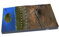
A) it will be rifted in two, forming a new ocean basin
B) it will be carried farther out to sea by seafloor spreading
C) it will be carried toward and collide with the continent
D) there was no small piece of continent offshore in the ocean
F) C) and D)
Correct Answer

verified
Correct Answer
verified
Multiple Choice
How will future tectonic events change the thickness of the crust? 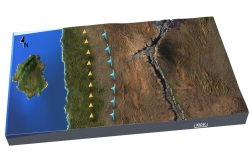
A) it will thin the crust along the west coast and the east coast
B) it will thin the crust along the west coast and thicken the crust along the east coast
C) it will thicken the crust along the west coast and thin the crust along the east coast
D) it will thicken the crust along both the west and east coast
F) A) and D)
Correct Answer

verified
Correct Answer
verified
Multiple Choice
Volcanism creates mountains that are:
A) sometimes local and not accompanied by regional increases in crustal thickness
B) formed of piled volcanic material, such as scoria, ash, lava flows, debris flows, and mudslides
C) varied in size from small cinder cones to large shield and composite volcanoes
D) all of these are types of mountains created by volcanism
F) B) and C)
Correct Answer

verified
Correct Answer
verified
Multiple Choice
A prism- or wedge-shaped, structurally complex zone of faults, folds, and mostly metamorphosed rocks that form along the upper parts of a subduction zone where sedimentary material and oceanic crust are scraped off the downgoing slab is called an) :
A) accretionary prism
B) subduction wedge
C) foreland basin
D) passive margin
F) C) and D)
Correct Answer

verified
Correct Answer
verified
Multiple Choice
Which numbered area on this geologic map of North America consists of recently added tectonic terranes? 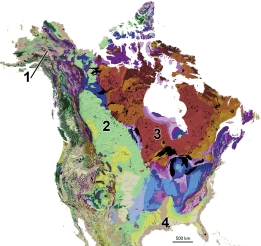
A) 1, southern Alaska
B) 2, continental platform of west-central Canada
C) 3, continental shield of eastern Canada
D) 4, coastal plain along the Gulf Coast of the U.S.
F) B) and D)
Correct Answer

verified
Correct Answer
verified
Multiple Choice
Which of the following is NOT a type of terrane in California?
A) oceanic crust
B) island arcs
C) accretionary prism
D) displaced granitic rocks
E) all of these are present in California
G) B) and E)
Correct Answer

verified
Correct Answer
verified
Multiple Choice
Numerous terranes exist in Alaska. One of these is the Wrangellia terrane. Why is the Wrangellia terrane considered part of the same terrane as that from pieces scattered from western Idaho northward to Alaska?
A) The terranes have similar ages and sequences of rocks.
B) The terranes are joined by a single fault line.
C) The terranes are of distinctly different rock types from each other.
D) The terranes were formed during increasingly older times as they progress northwest.
F) C) and D)
Correct Answer

verified
Correct Answer
verified
Multiple Choice
The average thickness of oceanic crust is:
A) 7 km
B) 5 km
C) 50 km
D) 12 km
F) All of the above
Correct Answer

verified
Correct Answer
verified
Multiple Choice
What type of basin is shown in this figure? 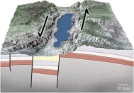
A) passive margin
B) normal-fault basin
C) foreland basin
D) basin along a strike-slip fault
F) A) and C)
Correct Answer

verified
Correct Answer
verified
Multiple Choice
How can we tell that the Himalaya has been uplifted?
A) uplift can be measured with a global positioning system GPS)
B) deep rocks are exposed at the surface and yield young isotopic ages
C) the top of Mount Everest contains a limestone with marine fossils
D) all of these
F) C) and D)
Correct Answer

verified
Correct Answer
verified
Multiple Choice
Which of the following regions below would you predict to have the thickest continental crust? 
A) the West Coast because it is close to the plate boundary
B) the Colorado Rockies and adjacent Great Plains
C) the area with thick sediments around the Mississippi River
D) the Appalachian Mountains, the dominant range in the eastern U.S.
E) the East Coast because it is a passive margin
G) A) and B)
Correct Answer

verified
Correct Answer
verified
Multiple Choice
Which numbered site is likely to have a thin sequence of sediments over crystalline rocks of the basement? 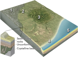
A) 1, the continental shield
B) 2, the continental platform
C) 3, a basin in the continent
D) 4, a continental shelf
E) 5, a deep sediment-filled basin next to the continent
G) B) and C)
Correct Answer

verified
Correct Answer
verified
Multiple Choice
What geologic setting is expressed by the formation of the Sierra Nevada and adjacent features? 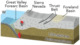
A) a continental collision east of to the right of) the Sierra Nevada
B) an ocean-continent convergent zone
C) a continental rifting event east of to the right of) the Sierra Nevada
D) continental rifting west to the left of) of the Sierra Nevada
F) A) and C)
Correct Answer

verified
Correct Answer
verified
Multiple Choice
Which of the following is NOT the name of a supercontinent?
A) Gondwana
B) Laurasia
C) Pangaea
D) Rodinia
E) Tethys
G) A) and C)
Correct Answer

verified
Correct Answer
verified
Showing 21 - 40 of 124
Related Exams